
File:Bosnie et Sandjak 1904.svg

此SVG文件的PNG预览的大小:657 × 600像素。 其他分辨率:263 × 240像素 | 526 × 480像素 | 841 × 768像素 | 1,122 × 1,024像素 | 2,243 × 2,048像素 | 2,000 × 1,826像素。
原始文件 (SVG文件,尺寸为2,000 × 1,826像素,文件大小:139 KB)
摘要
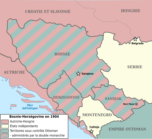
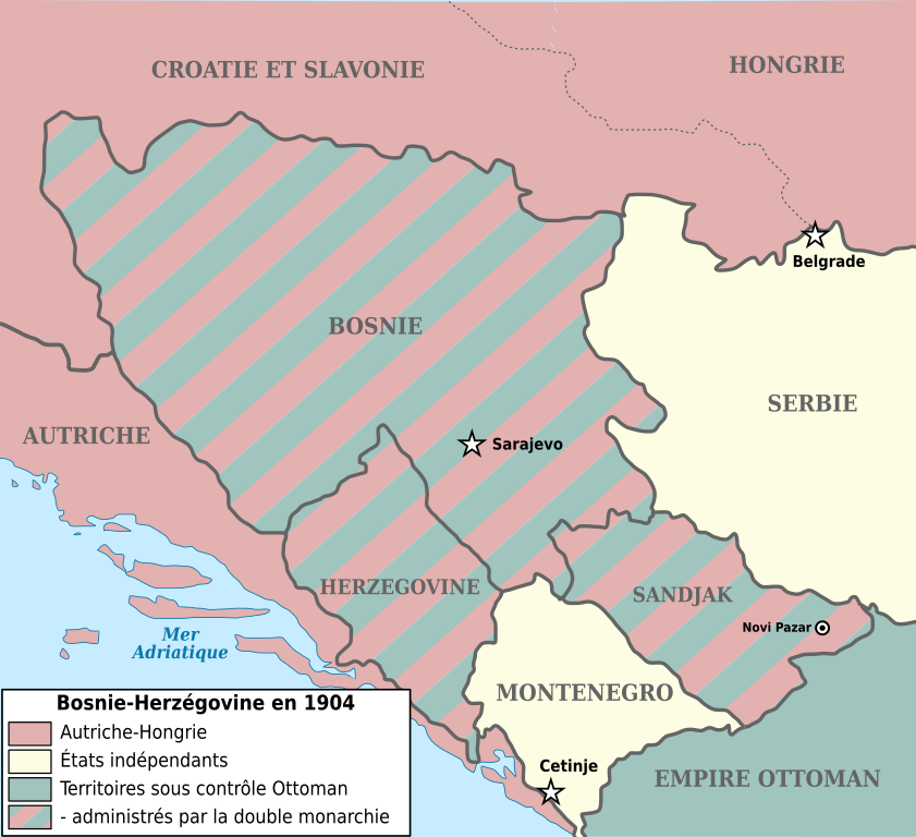
| 描述 | Map showing Bosnia-Herzegovina and the Sanjak of Novibazar (1904). |
| 日期 | (UTC) |
| 来源 | |
| 作者 |
|
| 其他版本 |
此文件衍生的作品: |
| 这是一张修改过的图片,这意味着它已在原版本的基础上通过软件进行了编辑。其原始版本为:Bosnia-Herzegovina and Sanjak of Novibazar.JPG。
|

|
已授权您依据自由软件基金会发行的无固定段落及封面封底文字(Invariant Sections, Front-Cover Texts, and Back-Cover Texts)的GNU自由文件许可协议1.2版或任意后续版本的条款,复制、传播和/或修改本文件。该协议的副本请见“GNU Free Documentation License”。 |
| 本文件采用知识共享署名-相同方式共享 3.0 未本地化版本许可协议授权。 | ||
| ||
| 本许可协议标签作为GFDL许可协议更新的组成部分被添加至本文件。 |
原始上传日志
This image is a derivative work of the following images:
- Image:Bosnia-Herzegovina_and_Sanjak_of_Novibazar.JPG licensed with PD-US
- 2008-07-29T10:34:31Z Rcbutcher 5696x5200 (17763428 Bytes) {{Information |Description=Map showing Bosnia-Herzegovina and the Sanjak of Novibazar. |Source=The Century Dictionary and Cyclopedia, Vol X, Map No. 89, Copyright 1897 and 1902; Cyclopedia itself, Copyright 1889, 1890, 1891..
Uploaded with derivativeFX
文件历史
点击某个日期/时间查看对应时刻的文件。
| 日期/时间 | 缩略图 | 大小 | 用户 | 备注 | |
|---|---|---|---|---|---|
| 当前 | 2018年1月1日 (一) 16:34 | | 2,000 × 1,826(139 KB) | Flappiefh | Police DejaVu uniformisée, frontières inter-états plus marquées, changement du titre en légende. |
| 2017年12月30日 (六) 15:25 |  | 2,000 × 1,826(129 KB) | Flappiefh | Modification apportées à la demande du Conteur (https://fr.wikipedia.org/wiki/Utilisateur:Conteur-momentanement-indisponible) via l'Atelier Cartes. Au programme : légende refaite, frontières en gris, Dalmatie remplacée par Autriche, une frontière... | |
| 2013年5月2日 (四) 20:39 |  | 2,000 × 1,826(82 KB) | Fulvio314 | Removed black artifact (Inkscape issue) | |
| 2012年12月29日 (六) 14:31 |  | 2,000 × 1,826(108 KB) | Ciaurlec | Moved Dynamic text to simple text | |
| 2009年5月30日 (六) 08:03 |  | 2,000 × 1,826(109 KB) | Le serbe | (ajoute légende des états "avant blanc"(Serbie, Monténégro) La Hongrie n'est pas l'Autriche-Hongrie mais juste la Hongrie. L'Albanie et la Macédoine ne sont pas, la Turquie. La Turquie n'existe pas à l'époque, on parle d'empire ottoman. ) | |
| 2009年5月30日 (六) 08:02 |  | 2,000 × 1,826(109 KB) | Le serbe | ajoute légende des états "avant blanc"(Serbie, Monténégro) La Hongrie n'est pas l'Autriche-Hongrie mais juste la Hongrie. L'Albanie et la Macédoine ne sont pas, la Turquie. La Turquie n'existe pas à l'époque, on parle d'empire ottoman. | |
| 2008年9月16日 (二) 11:59 |  | 2,000 × 1,826(163 KB) | Tinodela | {{Information |Description= |Source= |Date= |Author= |Permission= |other_versions= }} | |
| 2008年9月16日 (二) 11:58 |  | 2,000 × 1,826(87 KB) | Tinodela | {{Information |Description=Map showing Bosnia-Herzegovina and the Sanjak of Novibazar (1904). |Source=*Image:Bosnia-Herzegovina_and_Sanjak_of_Novibazar.JPG |Date=2008-09-16 11:57 (UTC) |Author=*derivative work: ~~~ *[[:Image:Bosnia-Herzegovina_and_S |
文件用途
没有页面链接到本图像。
全域文件用途
以下其他wiki使用此文件:
- el.wikipedia.org上的用途
- en.wikipedia.org上的用途
- fi.wikipedia.org上的用途
- fr.wikipedia.org上的用途