
File:Central pivot irrigation.jpg

本预览的尺寸:800 × 458像素。 其他分辨率:320 × 183像素 | 640 × 366像素 | 1,280 × 732像素。
原始文件 (1,280 × 732像素,文件大小:180 KB,MIME类型:image/jpeg)
摘要
| 描述 |
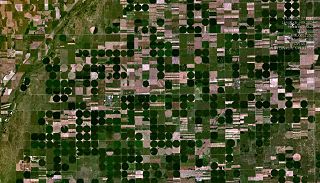
Descriptionw:Central pivot irrigation in the w:U.S., around w:Lewis, Kansas w:NASA Worldwind image. worldwind://goto/world=Earth&lat=37.94378&lon=-99.19244&alt=24232&dir=0.6 |
| 来源 | 本檔案是由FastilyClone使用MTC!,從en.wikipedia轉移到維基共享資源。 |
| 作者 | 原上传者为维基百科的Toytoy |
许可协议
| 本圖像屬於公有領域,因其為NASA的World Wind衛星地圖瀏覽器的一張截圖,且使用了公有領域圖層,如Blue Marble、MODIS、Landsat、SRTM、USGS、GLOBE等。
|
 |
| 相机位置 | | 在以下服务上查看本图像和附近其他图像: OpenStreetMap |
|---|
原始上传日志
原始描述頁面位於這裡。下列使用者名稱均來自en.wikipedia。
| 日期/时间 | 大小 | 用户 | 备注 |
|---|---|---|---|
| 2005-06-03 13:11:49 | 1280× 732× | Toytoy | |
| 2005-06-03 10:59:39 | 514× 603× | Toytoy | [[Central pivot irrigation]] Image obtained from http://www.worldwindcentral.com/wiki/Image:Pivot_irrigation.jpg . {{PD}} |
文件历史
点击某个日期/时间查看对应时刻的文件。
| 日期/时间 | 缩略图 | 大小 | 用户 | 备注 | |
|---|---|---|---|---|---|
| 当前 | 2016年7月22日 (五) 03:56 | | 1,280 × 732(180 KB) | OgreBot | (BOT): Reverting to most recent version before archival |
| 2016年7月22日 (五) 03:56 |  | 514 × 603(38 KB) | OgreBot | (BOT): Uploading old version of file from en.wikipedia; originally uploaded on 2005-06-03 10:59:39 by Toytoy | |
| 2016年7月21日 (四) 06:33 |  | 1,280 × 732(180 KB) | FastilyClone | Transferred from en.wikipedia (MTC!) |
文件用途
以下页面使用本文件:
全域文件用途
以下其他wiki使用此文件:
- ar.wikipedia.org上的用途
- arz.wikipedia.org上的用途
- ca.wikipedia.org上的用途
- ceb.wikipedia.org上的用途
- ce.wikipedia.org上的用途
- en.wikipedia.org上的用途
- es.wikipedia.org上的用途
- eu.wikipedia.org上的用途
- fr.wikipedia.org上的用途
- ht.wikipedia.org上的用途
- it.wikipedia.org上的用途
- lld.wikipedia.org上的用途
- no.wikipedia.org上的用途
- pl.wikipedia.org上的用途
- pt.wikipedia.org上的用途
- sr.wikipedia.org上的用途
- tt.wikipedia.org上的用途
- uk.wikipedia.org上的用途
- ur.wikipedia.org上的用途
- uz.wikipedia.org上的用途
- vi.wikipedia.org上的用途
- www.wikidata.org上的用途
- zh-min-nan.wikipedia.org上的用途