
File:South Williamson Kentucky aerial view.jpg

預覽大小:800 × 534 像素。 其他解析度:320 × 214 像素 | 640 × 427 像素 | 1,024 × 683 像素 | 1,500 × 1,001 像素。
原始檔案 (1,500 × 1,001 像素,檔案大小:814 KB,MIME 類型:image/jpeg)
| 描述 |
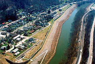
English: Aerial view of South Williamson, Kentucky, USA. The town is protected by a floodwall built along the Tug Fork River by the U.S. Army Corps of Engineers. The river here is the border between Kentucky and West Virginia. The view in this photograph is from the West Virginia side looking south-southwest over the river to South Williamson, Kentucky. |
|||
| 圖中地點 | South Williamson, Kentucky, USA 37°40′20.97″N 82°17′4.92″W / 37.6724917°N 82.2847°W |
|||
| 日期 | ||||
| 來源 |
U.S. Army Corps of Engineers Digital Visual Library Image page Image description page Digital Visual Library home page |
|||
| 作者 | U.S. Army Corps of Engineers, photographer not specified or unknown | |||
| 授權許可 (重用此檔案) |
|
檔案歷史
點選日期/時間以檢視該時間的檔案版本。
| 日期/時間 | 縮圖 | 尺寸 | 使用者 | 備註 | |
|---|---|---|---|---|---|
| 目前 | 2007年3月22日 (四) 01:21 | | 1,500 × 1,001(814 KB) | DanMS | {{Information | Description = {{en|Aerial view of South Williamson, Kentucky, USA. The town is protected by a floodwall built along the Tug Fork River by the U.S. Army Corps of Engineers.}} | Source = U.S. Army Corps of Engineers Digital Visual |
檔案用途
下列頁面有用到此檔案:
全域檔案使用狀況
以下其他 wiki 使用了這個檔案:
- azb.wikipedia.org 的使用狀況
- ceb.wikipedia.org 的使用狀況
- ce.wikipedia.org 的使用狀況
- en.wikipedia.org 的使用狀況
- es.wikipedia.org 的使用狀況
- fa.wikipedia.org 的使用狀況
- lld.wikipedia.org 的使用狀況
- pl.wikipedia.org 的使用狀況
- sr.wikipedia.org 的使用狀況
- tt.wikipedia.org 的使用狀況
- uk.wikipedia.org 的使用狀況
- www.wikidata.org 的使用狀況