
File:Zubair ali 2012007.jpg
預覽大小:600 × 600 像素。 其他解析度:240 × 240 像素 | 480 × 480 像素 | 720 × 720 像素。
原始檔案 (720 × 720 像素,檔案大小:126 KB,MIME 類型:image/jpeg)
| 描述 |
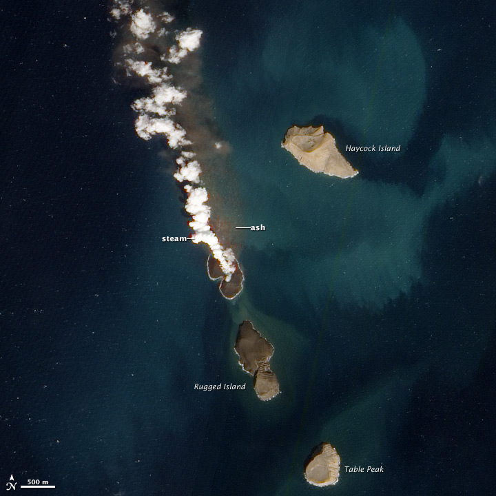
English: New volcanic island in the Red Sea. A new island is forming in the Red Sea. About 60 kilometers (40 miles) from the coast of Yemen, an undersea eruption began in mid-December 2011. Local fishermen reported an eruption near the island of Saba, while satellites captured a white plume rising from the sea, and a pulse of sulfor dioxide. The activity was located on the northern edge of the Zubair Islands . |
|||||
| 日期 | acquired January 7, 2012 | |||||
| 來源 | http://earthobservatory.nasa.gov/NaturalHazards/view.php?id=76911 | |||||
| 作者 | NASA Advanced Land Imager (ALI) aboard the Earth Observing-1 (EO-1) satellite. | |||||
| 授權許可 (重用此檔案) |
|

檔案歷史
點選日期/時間以檢視該時間的檔案版本。
| 日期/時間 | 縮圖 | 尺寸 | 使用者 | 備註 | |
|---|---|---|---|---|---|
| 目前 | 2012年1月24日 (二) 17:51 | | 720 × 720(126 KB) | Tillman | {{Information |Description ={{en|1=New Volcanic Island in the Red Sea. A new island is forming in the Red Sea. About 60 kilometers (40 miles) from the coast of Yemen, an undersea eruption began in mid-December 2011. Local fishermen reported an eruption |
檔案用途
下列頁面有用到此檔案:
全域檔案使用狀況
以下其他 wiki 使用了這個檔案:
- ar.wikipedia.org 的使用狀況
- arz.wikipedia.org 的使用狀況
- de.wikipedia.org 的使用狀況
- en.wikipedia.org 的使用狀況
- he.wikipedia.org 的使用狀況
- it.wikipedia.org 的使用狀況
- ja.wikipedia.org 的使用狀況
- nn.wikipedia.org 的使用狀況
- pt.wikipedia.org 的使用狀況
- ru.wikipedia.org 的使用狀況
- uk.wikipedia.org 的使用狀況
- www.wikidata.org 的使用狀況