
File:Aksai Chin Sino-Indian border map.png

原始檔案 (624 × 872 像素,檔案大小:102 KB,MIME 類型:image/png)
摘要

|
File:Aksai Chin Sino-Indian border map.svg是本檔案的向量版本。 如果品質不低,就應該優先使用該檔案,而非PNG檔案。
File:Aksai Chin Sino-Indian border map.png → File:Aksai Chin Sino-Indian border map.svg
更多資訊請參閱Help:SVG/zh。 |
 |
| 描述 |
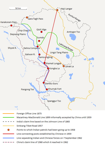
English: The map shows the Indian and Chinese claims of the border in the Aksai Chin region, the Macartney-MacDonald line, the Foreign Office Line, as well as the progress of Chinese forces as they occupied areas during the Sino-Indian War. |
| 日期 | |
| 來源 | 自己的作品 |
| 作者 | The Discoverer |
The Macartney-MacDonald line is described as follows: "From the Karakoram Pass the crests of the range run nearly east for about half a degree, and then turn south to a little below the 35th parallel.. Rounding... the source of the Karakash, the line of hills to be followed runs north-east to a point east of Kizil Jilga and from there, in a south-easterly direction, follows the Lak Tsung (Lokzhung) Range until that meets a spur.. which has hitherto been shown on our maps as the eastern boundary of Ladakh.[1]
The Macartney-MacDonald line was never accepted by China, although they informally indicated acceptance on certain occasions:
- Woodman, Dorothy (1969年) 《 Himalayan Frontiers: A Political Review of British, Chinese, Indian, and Russian Rivalries》、Praeger、第102頁 "The proposed boundary seems never to have been considered in the same form again until Alastair Lamb revived it in 1964."
- Lamb, Alastair (1965). "Treaties, Maps and the Western Sector of the Sino-Indian Boundary Dispute". The Australian Year Book of International Law. "Unfortunately, the Chinese never replied formally to the note, though they indicated informally on a number of occasions their agreement as to its boundary alignment."
In 1959, Chou confirmed the new Chinese claim line to Nehru.
References: [2] archive copy at the Wayback Machine [3] [4] [5] [6] Map on last page archive copy at the Wayback Machine [7]
![[2]](http://cpasindia.org/images/sino-india1.jpg)
![[3]](http://www.frontline.in/static/html/fl2018/images/20030912002104801.jpg)
![[4]](http://www.frontline.in/static/html/fl2018/images/20030912002104802.jpg)
![[5]](http://www.frontline.in/static/html/fl2320/images/20061020001608505.jpg)
![[6]](http://www.indiandefencereview.com/wp-content/uploads/2013/06/Aksai-Chin-GOI-Map.jpg)
授權條款
- 您可以自由:
- 分享 – 複製、發佈和傳播本作品
- 重新修改 – 創作演繹作品
- 惟需遵照下列條件:
- 姓名標示 – 您必須指名出正確的製作者,和提供授權條款的連結,以及表示是否有對內容上做出變更。您可以用任何合理的方式來行動,但不得以任何方式表明授權條款是對您許可或是由您所使用。
- 相同方式分享 – 如果您利用本素材進行再混合、轉換或創作,您必須基於如同原先的相同或兼容的條款,來分布您的貢獻成品。
檔案歷史
點選日期/時間以檢視該時間的檔案版本。
| 日期/時間 | 縮圖 | 尺寸 | 用戶 | 備註 | |
|---|---|---|---|---|---|
| 目前 | 2020年9月7日 (一) 20:06 | | 624 × 872(102 KB) | The Discoverer | Removed Tibet-Sinkiang boundary, added label for Amtogor Tso. |
| 2020年6月9日 (二) 02:51 |  | 624 × 872(102 KB) | MarkH21 | Intended change from the last edit (i.e. latest version with "informally" per references in talk discussion) | |
| 2020年6月9日 (二) 02:29 |  | 624 × 872(101 KB) | MarkH21 | Reverted to version as of 00:21, 7 February 2018 (UTC) This was the previous version; the addition of “accepted by China until 1959” was the contested change, not the revert to the original description (the refs are also now dead, but previously said tacit acceptance which isn’t outright acceptance) | |
| 2018年4月23日 (一) 19:37 |  | 624 × 872(102 KB) | The Discoverer | Reverted to version as of 09:10, 13 December 2017 (UTC) The file of 12 December removes a statement that is supported by the source. As per COM:OVERWRITE, "Controversial or contested changes should be uploaded to a separate filename" | |
| 2018年2月7日 (三) 00:21 |  | 624 × 872(101 KB) | 樂號 | Reverted to version as of 23:05, 12 December 2017 (UTC) | |
| 2017年12月13日 (三) 09:10 |  | 624 × 872(102 KB) | The Discoverer | Reverted to version as of 11:07, 19 February 2017 (UTC) The file of 12 December removes a statement that is supported by the source. As per COM:OVERWRITE, "Controversial or contested changes should be uploaded to a separate filename" | |
| 2017年12月12日 (二) 23:05 |  | 624 × 872(101 KB) | 樂號 | Macartney–MacDonald Line is only proposed by Britain No official accept made by China | |
| 2017年2月19日 (日) 11:07 |  | 624 × 872(102 KB) | The Discoverer | Added Karakoram Pass and Kunlun Range | |
| 2015年4月1日 (三) 15:26 |  | 624 × 872(59 KB) | RokerHRO | optipng -o7 -i0 → 40.77% decrease | |
| 2014年10月2日 (四) 15:00 |  | 624 × 872(99 KB) | The Discoverer | Uploaded correct file with scale added. |
檔案用途
全域檔案使用狀況
以下其他 wiki 使用了這個檔案:
- ast.wikipedia.org 的使用狀況
- as.wikipedia.org 的使用狀況
- az.wikipedia.org 的使用狀況
- bh.wikipedia.org 的使用狀況
- bn.wikipedia.org 的使用狀況
- ca.wikipedia.org 的使用狀況
- de.wikipedia.org 的使用狀況
- en.wikipedia.org 的使用狀況
- es.wikipedia.org 的使用狀況
- fr.wikipedia.org 的使用狀況
- hi.wikipedia.org 的使用狀況
- id.wikipedia.org 的使用狀況
- it.wikipedia.org 的使用狀況
- ja.wikipedia.org 的使用狀況
- ka.wikipedia.org 的使用狀況
- kn.wikipedia.org 的使用狀況
- ko.wikipedia.org 的使用狀況
- lv.wikipedia.org 的使用狀況
- ml.wikipedia.org 的使用狀況
- ms.wikipedia.org 的使用狀況
- nl.wikipedia.org 的使用狀況
- no.wikipedia.org 的使用狀況
- or.wikipedia.org 的使用狀況
- pl.wikipedia.org 的使用狀況
- pt.wikipedia.org 的使用狀況
- ro.wikipedia.org 的使用狀況
- ru.wikipedia.org 的使用狀況
- ru.wikinews.org 的使用狀況
- sr.wikipedia.org 的使用狀況
- ta.wikipedia.org 的使用狀況
- te.wikipedia.org 的使用狀況
- uk.wikipedia.org 的使用狀況
- vi.wikipedia.org 的使用狀況
檢視此檔案的更多全域使用狀況。