
File:Eyjafjallajökull volcanic ash composite.png

預覽大小:600 × 600 像素。 其他解析度:240 × 240 像素 | 480 × 480 像素 | 726 × 726 像素。
原始檔案 (726 × 726 像素,檔案大小:95 KB,MIME 類型:image/png)
| 描述 |
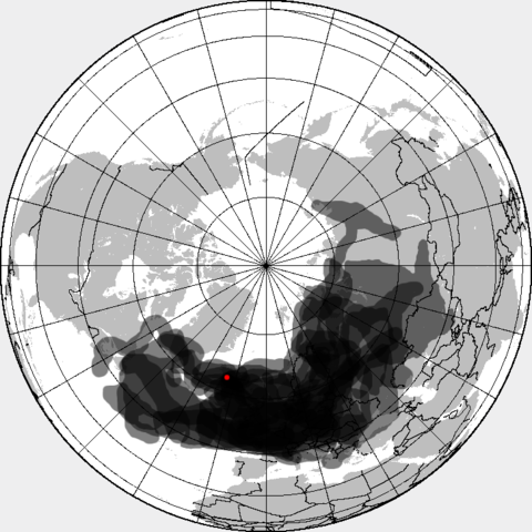
This is a composite map showing the position of the Icelandinc volcanic ash cloud that closed European air space in different days. Based on maps found at http://www.metoffice.gov.uk/aviation/vaac/vaacuk_vag.html Days included:
|
| 日期 | (UTC) |
| 來源 | |
| 作者 |
|
| 這是一張修飾過的圖片,即本圖片是用軟體修改過後的版本,修改的方式或內容有:made all day layers visible。原版圖片來源:Eyjafjallajökull volcanic ash multilayer.xcf。修改者:Cogiati。
|
我,本作品的著作權持有者,決定用以下授權條款發佈本作品:
此檔案採用共享創意 姓名標示-相同方式分享 3.0 未在地化版本授權條款。
- 您可以自由:
- 分享 – 複製、發佈和傳播本作品
- 重新修改 – 創作演繹作品
- 惟需遵照下列條件:
- 姓名標示 – 您必須指名出正確的製作者,和提供授權條款的連結,以及表示是否有對內容上做出變更。您可以用任何合理的方式來行動,但不得以任何方式表明授權條款是對您許可或是由您所使用。
- 相同方式分享 – 如果您利用本素材進行再混合、轉換或創作,您必須基於如同原先的相同或兼容的條款,來分布您的貢獻成品。
原始上傳日誌
This image is a derivative work of the following images:
- File:Eyjafjallajökull_volcanic_ash_multilayer.xcf licensed with Cc-by-sa-3.0
- 2010-04-25T01:29:03Z Cogiati 0x0 (853897 Bytes) added 22 april
- 2010-04-25T01:17:42Z Cogiati 0x0 (845598 Bytes) added 21 april
- 2010-04-25T00:01:51Z Cogiati 0x0 (832938 Bytes) added 19 april
- 2010-04-24T23:20:51Z Cogiati 0x0 (818621 Bytes) added 24 april
- 2010-04-23T21:13:03Z Cogiati 0x0 (814673 Bytes) added 15 april
- 2010-04-23T20:54:25Z Cogiati 0x0 (808456 Bytes) {{Information |Description=This map shows the Icelandic volcanic ash cloud that closed European air space. Every day is shown in a different layer. It's an XCf file editable with GIMP. Based on maps found at http://www.metoff
Uploaded with derivativeFX
檔案歷史
點選日期/時間以檢視該時間的檔案版本。
| 日期/時間 | 縮圖 | 尺寸 | 用戶 | 備註 | |
|---|---|---|---|---|---|
| 目前 | 2010年4月27日 (二) 14:53 | | 726 × 726(95 KB) | Cogiati | added 17 april |
| 2010年4月26日 (一) 14:09 |  | 726 × 726(93 KB) | Cogiati | added 18 april | |
| 2010年4月26日 (一) 07:32 |  | 726 × 726(92 KB) | Cogiati | added 25 April | |
| 2010年4月25日 (日) 16:00 |  | 726 × 726(91 KB) | Cogiati | added 16 april | |
| 2010年4月25日 (日) 01:56 |  | 726 × 726(90 KB) | Cogiati | added 20 april | |
| 2010年4月25日 (日) 01:32 |  | 726 × 726(88 KB) | Cogiati | {{Information |Description=This is a composite map showing the position of the Icelandinc volcanic ash cloud that closed European air space in different days. Based on maps found at http://www.metoffice.gov.uk/aviation/vaac/vaacuk_vag.html Days included: |
檔案用途
下列頁面有用到此檔案:
全域檔案使用狀況
以下其他 wiki 使用了這個檔案:
- ca.wikipedia.org 的使用狀況
- da.wikipedia.org 的使用狀況
- de.wikipedia.org 的使用狀況
- en.wikipedia.org 的使用狀況
- es.wikipedia.org 的使用狀況
- eu.wikipedia.org 的使用狀況
- fi.wikipedia.org 的使用狀況
- hu.wikipedia.org 的使用狀況
- it.wikipedia.org 的使用狀況
- ja.wikipedia.org 的使用狀況
- pnb.wikipedia.org 的使用狀況
- pt.wikipedia.org 的使用狀況
- ru.wikipedia.org 的使用狀況
- th.wikipedia.org 的使用狀況
- ur.wikipedia.org 的使用狀況
- vi.wikipedia.org 的使用狀況