
File:Flag-map of the world (1914).png
預覽大小:800 × 397 像素。 其他解析度:320 × 159 像素 | 640 × 318 像素 | 1,024 × 508 像素 | 1,280 × 635 像素 | 2,560 × 1,271 像素 | 4,500 × 2,234 像素。
原始檔案 (4,500 × 2,234 像素,檔案大小:529 KB,MIME 類型:image/png)
.png?uselang=zh-mo)
.png?uselang=zh-mo)
.png?action=history&uselang=zh-mo)
.png)

|
本圖片是以PNG、GIF或JPEG格式上傳。然而,其中包含的資料或訊息,應該重新建立成可縮放向量圖形(SVG)檔案,以更有效率或更準確的方式儲存。如有可能,請上傳本圖片的SVG格式版本。在上傳之後,請修改維基各姊妹計畫中所有使用舊版圖片的條目(列在圖像連結章節中),替換為新版圖片,並在舊圖片的描述頁中加入{{Vector version available|新圖片名稱.svg}}模板,同時移除本模板。
|
摘要
| 描述 |
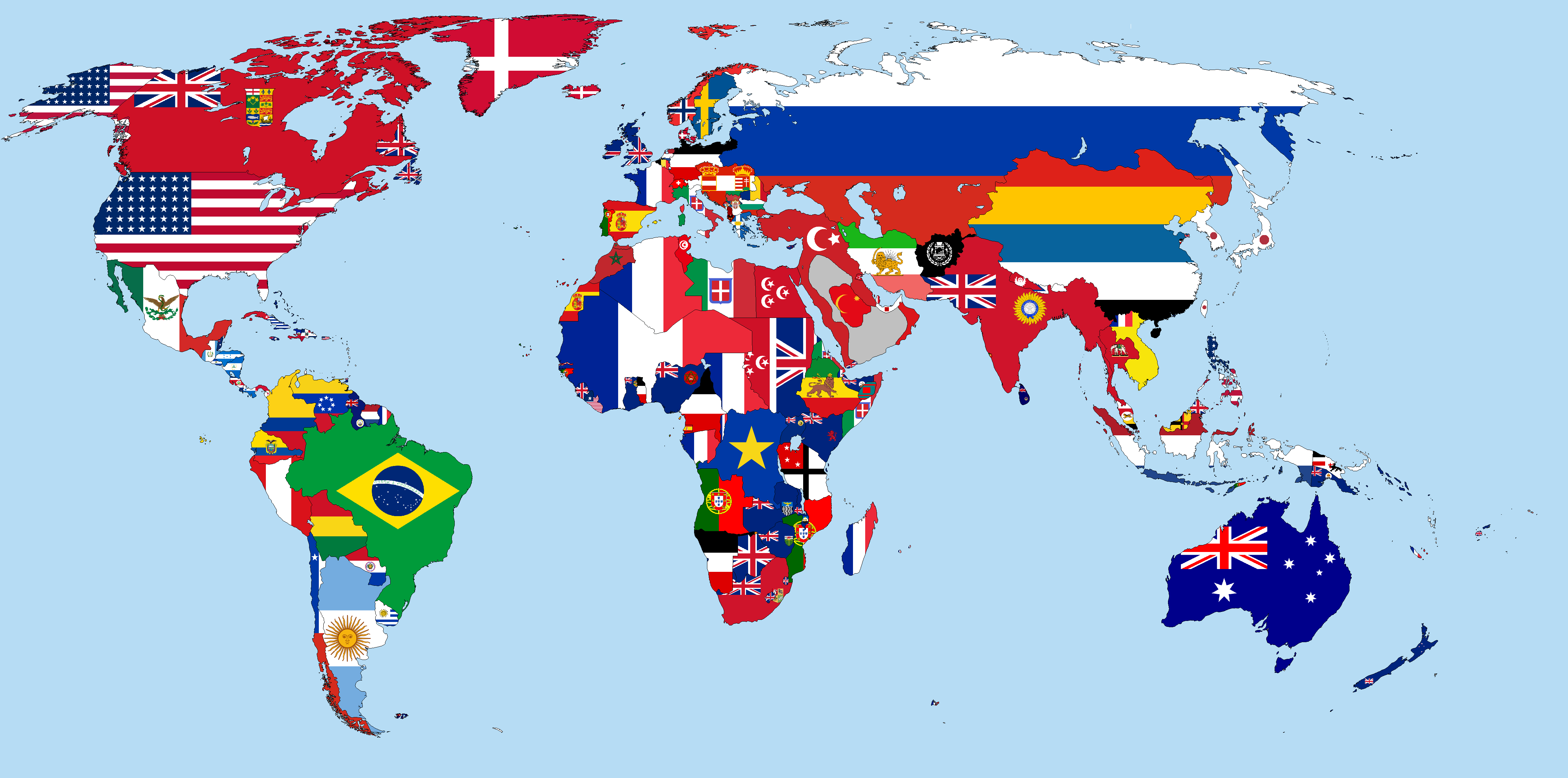
English: This is a world map in 1914, which shows flags of countries and colonies covering their territory. It is in Kavrayskiy VII projection.
|
|||||
| 日期 | ||||||
| 來源 | 自己的作品 | |||||
| 作者 | Alvin Lee | |||||
.png)
.png)
.png)
.png)
.png)
.png)
.png)
.png)
.png)
.png)
.png)
.png)
.png)
.png)
.png)
.png)
.png)
.png)
.png)
.png)
.png)
.png)
.png)
.png)
.png)
.png)
.png)
.png)
.png)
授權條款
我,本作品的著作權持有者,決定用以下授權條款發佈本作品:
此檔案採用共享創意 姓名標示-相同方式分享 3.0 未在地化版本授權條款。
- 您可以自由:
- 分享 – 複製、發佈和傳播本作品
- 重新修改 – 創作演繹作品
- 惟需遵照下列條件:
- 姓名標示 – 您必須指名出正確的製作者,和提供授權條款的連結,以及表示是否有對內容上做出變更。您可以用任何合理的方式來行動,但不得以任何方式表明授權條款是對您許可或是由您所使用。
- 相同方式分享 – 如果您利用本素材進行再混合、轉換或創作,您必須基於如同原先的相同或兼容的條款,來分布您的貢獻成品。
檔案歷史
點選日期/時間以檢視該時間的檔案版本。
.png&variant=zh-mo&dir=prev)
.png&variant=zh-mo&offset=20150128231755)
.png&variant=zh-mo&offset=&limit=20)
.png&variant=zh-mo&offset=&limit=50)
.png&variant=zh-mo&offset=&limit=100)
.png&variant=zh-mo&offset=&limit=250)
.png&variant=zh-mo&offset=&limit=500)
| 日期/時間 | 縮圖 | 尺寸 | 用戶 | 備註 | |
|---|---|---|---|---|---|
| 目前 | 2023年8月11日 (五) 00:28 | | 4,500 × 2,234(529 KB) | Поль Крол Злой Диктатор | Reverted to version as of 19:08, 28 February 2023 (UTC) |
| 2023年6月22日 (四) 14:58 |  | 4,500 × 2,234(540 KB) | NatoTheVideoEditor AUTTP 2023 Est. 2011 | Reverted to version as of 18:07, 19 November 2022 (UTC) | |
| 2023年2月28日 (二) 19:08 |  | 4,500 × 2,234(529 KB) | Marcomogollon | Ecuador has never had access to the Amazon River since its independence, this is a hoax without evidence. The region passed into Peruvian hands from the colony by means of a Royal Decree of 1802 | |
| 2022年11月19日 (六) 18:07 |  | 4,500 × 2,234(540 KB) | NSassin | Changed the Alaskan flag to that of the United States, and added a border around the Dervish State. | |
| 2022年1月27日 (四) 21:18 |  | 4,500 × 2,234(537 KB) | Randomastwritter | added dervish | |
| 2015年7月30日 (四) 19:50 |  | 4,500 × 2,234(537 KB) | NSassin | Reverted Arabia back to the Emirate of Jabal Shammar. | |
| 2015年3月25日 (三) 16:18 |  | 4,500 × 2,234(542 KB) | Alvin Lee | Removing Antarctica | |
| 2015年2月11日 (三) 21:25 |  | 4,500 × 2,583(560 KB) | NSassin | Made the flags of Goa and Timor Leste a little more clear and made the border of Mozambique smoother. | |
| 2015年2月5日 (四) 19:37 |  | 4,500 × 2,583(518 KB) | Carcaça Metáliaca | Fixing Goa and Timor Leste flags, and also fixing borders on Mozambique | |
| 2015年1月28日 (三) 23:17 |  | 4,500 × 2,583(560 KB) | NSassin | Fixed the flag of Nejd and Hasa, and Bhutan didn't have a flag until 1949 |
檔案用途
全域檔案使用狀況
以下其他 wiki 使用了這個檔案:
- ba.wikipedia.org 的使用狀況
- bg.wikipedia.org 的使用狀況
- de.wikipedia.org 的使用狀況
- en.wikipedia.org 的使用狀況
- es.wikipedia.org 的使用狀況
- hy.wikipedia.org 的使用狀況
- hyw.wikipedia.org 的使用狀況
- pt.wikipedia.org 的使用狀況
- ro.wikipedia.org 的使用狀況
- ru.wikipedia.org 的使用狀況
- sk.wikipedia.org 的使用狀況
.png)