
File:Looking north at LEnfant Plaza - Washington DC.jpg

預覽大小:800 × 505 像素。 其他解析度:320 × 202 像素 | 640 × 404 像素 | 1,024 × 646 像素 | 1,280 × 807 像素 | 2,912 × 1,837 像素。
原始檔案 (2,912 × 1,837 像素,檔案大小:1.14 MB,MIME 類型:image/jpeg)
摘要
| 描述 |
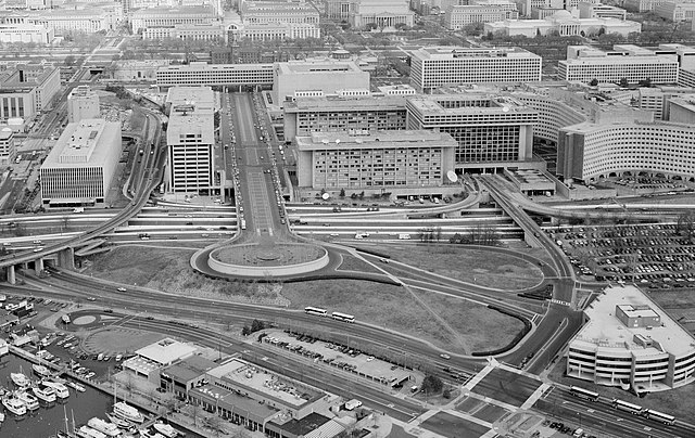
English: Aerial photograph looking north at L'Enfant Plaza, L'Enfant Promenade, and part of Southwest, Washington, D.C. (1992).
|
| 日期 | |
| 來源 | http://lcweb2.loc.gov/cgi-bin/displayPhoto.pl?path=/pnp/habshaer/dc/dc0700/dc0776/photos&topImages=042585pr.jpg |
| 作者 | U.S. National Park Service, Historic American Building Survey. John McWilliams, photographer. |
授權條款

|
This file comes from the Historic American Buildings Survey (HABS), Historic American Engineering Record (HAER) or Historic American Landscapes Survey (HALS). These are programs of the National Park Service established for the purpose of documenting historic places. Records consist of measured drawings, archival photographs, and written reports.
此標籤不表示文件的著作權狀態。任何文件在附有此標籤的同時還需要一個有效的著作權標籤。請參閱許可協議說明頁面以了解更多資訊。 |
| This image or media file contains material based on a work of a National Park Service employee, created as part of that person's official duties. As a work of the U.S. federal government, such work is in the public domain in the United States. See the NPS website and NPS copyright policy for more information. |
| 註解 | 該圖片含有註解:在維基媒體共享資源上查看註解 |
檔案歷史
點選日期/時間以檢視該時間的檔案版本。
| 日期/時間 | 縮圖 | 尺寸 | 用戶 | 備註 | |
|---|---|---|---|---|---|
| 目前 | 2011年3月6日 (日) 17:32 | | 2,912 × 1,837(1.14 MB) | Tim1965 | {{Information |Description ={{en|1=Aerial photograph looking north at L'Enfant Plaza. The Potomac River waterfront is at the bottom of the image. The six-lane divided street that is Maine Avenue SW can be seen just above the waterfront and its buildi |
檔案用途
下列頁面有用到此檔案:
全域檔案使用狀況
以下其他 wiki 使用了這個檔案:
- en.wikipedia.org 的使用狀況
- es.wikipedia.org 的使用狀況
- ru.wikipedia.org 的使用狀況
- www.wikidata.org 的使用狀況