
File:Hurricane Lane of 2000.JPG

預覽大小:476 × 599 像素。 其他解析度:191 × 240 像素 | 381 × 480 像素 | 610 × 768 像素 | 813 × 1,024 像素 | 1,627 × 2,048 像素 | 5,800 × 7,300 像素。
原始檔案 (5,800 × 7,300 像素,檔案大小:26.51 MB,MIME 類型:image/jpeg)
摘要
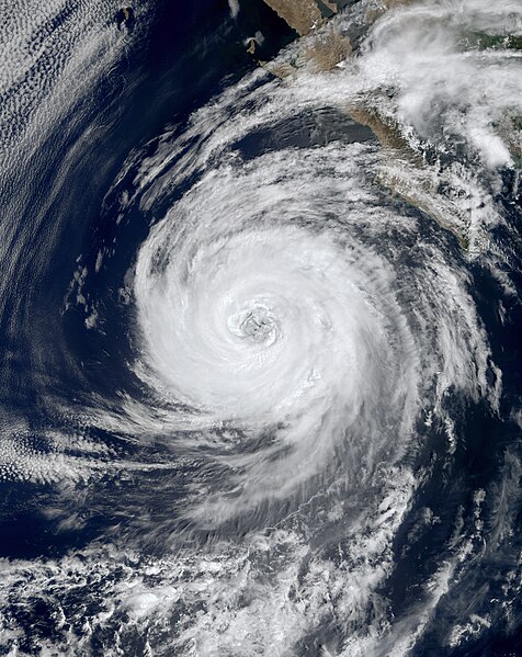
| 描述 | The spinning cloud pattern of Hurricane Lane is visible in this MODIS image from NASA's Terra satellite. Lane's maximum sustained winds were about 100 mph and its minimum central pressure was about 969 mb during the time of this image capture. | |||||
| 日期 | ||||||
| 來源 | http://visibleearth.nasa.gov/view_rec.php?id=1413 | |||||
| 作者 | Jacques Descloitres, MODIS Land Science Team | |||||
| 授權許可 (重用此檔案) |
|

檔案歷史
點選日期/時間以檢視該時間的檔案版本。
| 日期/時間 | 縮圖 | 尺寸 | 使用者 | 備註 | |
|---|---|---|---|---|---|
| 目前 | 2014年7月21日 (一) 09:05 | | 5,800 × 7,300(26.51 MB) | Supportstorm | Higher quality |
| 2010年1月2日 (六) 04:33 |  | 3,402 × 4,402(1.95 MB) | Juliancolton | Reverted to version as of 03:34, 20 September 2006 | |
| 2009年12月27日 (日) 17:12 |  | 3,420 × 4,372(1.65 MB) | Supportstorm | Image Touch up | |
| 2006年9月20日 (三) 03:34 |  | 3,402 × 4,402(1.95 MB) | Good kitty | higher res | |
| 2006年9月14日 (四) 07:20 |  | 463 × 600(47 KB) | Jake52 | Hurricane Lane of 2000 on September 11th. This image was taken by the MODIS instrument on the Terra satellite. Source: http://images.google.com/imgres?imgurl=http://veimages.gsfc.nasa.gov/1414/Lane.A2000255.1920_md.jpg&imgrefurl=http://visibleearth.nasa.g |
檔案用途
下列頁面有用到此檔案:
全域檔案使用狀況
以下其他 wiki 使用了這個檔案:
- en.wikipedia.org 的使用狀況