
File:Siege of Homs Map.svg

此 SVG 檔案的 PNG 預覽的大小:588 × 599 像素。 其他解析度:235 × 240 像素 | 471 × 480 像素 | 753 × 768 像素 | 1,005 × 1,024 像素 | 2,009 × 2,048 像素 | 883 × 900 像素。
原始檔案 (SVG 檔案,表面大小:883 × 900 像素,檔案大小:4.91 MB)
摘要
| 描述 |
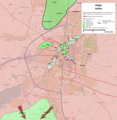
English: Map showing the current strategic situation in Homs as of January 2014.
Red represents area under Government control. Green represents Opposition control. |
||||
| 日期 | |||||
| 來源 | 自己的作品 | ||||
| 作者 | MrPenguin20 | ||||
| 其他版本 |
|


.svg)


.svg)


.svg)


_Territory_Change_2014-2016.gif)

_(within_Northern_Syria).svg)


.png)
.svg)


_map.png)
.svg)


.svg)


授權條款
| This work contains information from OpenStreetMap, which is made available under the Open Database License (ODbL).
The ODbL does not require any particular license for maps produced from ODbL data. Prior to 1 August 2020, map tiles produced by the OpenStreetMap Foundation were licensed under the CC-BY-SA-2.0 license. Maps produced by other people may be subject to other licences. |
我,本作品的著作權持有者,決定用以下授權條款發佈本作品:
此檔案採用創用CC 姓名標示-相同方式分享 3.0 未在地化版本授權條款。
- 您可以自由:
- 分享 – 複製、發佈和傳播本作品
- 重新修改 – 創作演繹作品
- 惟需遵照下列條件:
- 姓名標示 – 您必須指名出正確的製作者,和提供授權條款的連結,以及表示是否有對內容上做出變更。您可以用任何合理的方式來行動,但不得以任何方式表明授權條款是對您許可或是由您所使用。
- 相同方式分享 – 如果您利用本素材進行再混合、轉換或創作,您必須基於如同原先的相同或兼容的條款,來分布您的貢獻成品。
檔案歷史
點選日期/時間以檢視該時間的檔案版本。
| 日期/時間 | 縮圖 | 尺寸 | 使用者 | 備註 | |
|---|---|---|---|---|---|
| 目前 | 2018年8月3日 (五) 19:35 | | 883 × 900(4.91 MB) | Rr016 | Correction: rebels did not control that much north of Homs |
| 2017年12月10日 (日) 20:36 |  | 883 × 900(4.92 MB) | Kami888 | Made several changes to improve presentation, ask on talk page if any questions. | |
| 2017年10月9日 (一) 17:28 |  | 883 × 900(4.82 MB) | Rr016 | Fixes: added Shamas district, labeled more districts, fixed date of SAA offensive south of Homs, adjusted Bayada frontlines. | |
| 2017年10月8日 (日) 18:07 |  | 883 × 900(4.82 MB) | Rr016 | Major overhaul, inspired by Kami88's Battle of Qalamoun.svg layout. Map now shows all territory lost by opposition from 2012 - 2017. Used https://www.facebook.com/the.arab.chronicle/photos/a.454685571308535.1073741828.453010751476017/524550737655351/?t... | |
| 2014年5月11日 (日) 01:14 |  | 883 × 900(4.77 MB) | MrPenguin20 | Updated map to show current areas of control (will update further to show progression of siege). | |
| 2014年4月20日 (日) 23:02 |  | 883 × 900(4.77 MB) | MrPenguin20 | Update following recent offensives. | |
| 2014年4月8日 (二) 21:14 |  | 883 × 900(4.77 MB) | MrPenguin20 | Changed Dar al-Kabirah to contested. | |
| 2014年2月13日 (四) 22:53 |  | 883 × 900(4.77 MB) | MrPenguin20 | Updated map in line with https://pbs.twimg.com/media/BgWebW3CcAAJLbS.jpg:large | |
| 2014年2月4日 (二) 15:35 |  | 883 × 900(4.77 MB) | MrPenguin20 | Removed "Homs" from center of map. Reworked frontlines in line with map visible at http://online.wsj.com/news/articles/SB10001424052702303277704579346833918268994?mg=reno64-wsj&url=http%3A%2F%2Fonline.wsj.com%2Farticle%2FSB10001424052702303277704579346... | |
| 2014年1月30日 (四) 19:09 |  | 883 × 900(4.77 MB) | MrPenguin20 | Expanded area of opposition control north of Homs. |
檔案用途
下列頁面有用到此檔案:
全域檔案使用狀況
以下其他 wiki 使用了這個檔案:
- ar.wikipedia.org 的使用狀況
- azb.wikipedia.org 的使用狀況
- be.wikipedia.org 的使用狀況
- cs.wikipedia.org 的使用狀況
- en.wikipedia.org 的使用狀況
- es.wikipedia.org 的使用狀況
- fa.wikipedia.org 的使用狀況
- fr.wikipedia.org 的使用狀況
- hu.wikipedia.org 的使用狀況
- it.wikipedia.org 的使用狀況
- ja.wikipedia.org 的使用狀況
- nl.wikipedia.org 的使用狀況
- pl.wikipedia.org 的使用狀況
- ru.wikipedia.org 的使用狀況
- tr.wikipedia.org 的使用狀況
- www.wikidata.org 的使用狀況